California Adventure Part Five - I can hear you say, "What happened to parts one through four?"
Well, I'll tell you what happened ...

In 2020, I turned 65 and it also was my 40th year living in California. So, the original plan was to do one trip a month visiting all the corners of California and as many iconic places and parks as possible. I did write about part one back in early 2020. However, after Part 2 COVID hit, and I didn’t feel much like writing, in January 2021, I did finally write a blog summarizing what I’d been up to for the year. I was fortunate to be vaccinated in February 2021 and shortly thereafter resumed traveling with California Adventures 3, 4 and 5. I’ve not gotten around to documenting trips 3 and 4, but luckily for you, below is Part 5. Here’s a summary of the places visited on the adventures.
California Adventure 1 – January 2020
U.S. / Mexico Border - Tijuana River
Rose Bowl Floats - Pasadena
The Huntington – San Marino
Los Angeles Arboretum and Botanic Garden – Arcadia
The Walt Disney Concert Hall – Los Angeles
The Los Angeles Zoo – Griffin Park
The La Brea Tar Pits – Los Angeles
Santa Monica
Getty Museum – Malibu
Getty Center – Los Angeles
Palos Verdes
Laguna Beach
Mission San Juan Capistrano
California Adventure 2 – February 2020
Launch of SDSU Lady Elizabeth Rocket – Mojave Desert
Trona Pinnacles
Death Valley
Mojave National Preserve
Joshua Tree National Park
Living Desert – Palm Desert
California Adventure 3 – March 2021
Anza-Borrego Desert
Solvang
The Madonna Inn – San Luis Obispo
Mission San Miguel Archangel
Pinnacles National Park
Monterey Peninsula
Carmel Mission
Point Lobos State Preserve
Big Sur
Santa Barbara
Taft Gardens - Ojai
California Adventure 4 – April 2021
Wine Country Bike tour – Sonoma and Napa Counties
Point Reyes National Seashore
San Francisco Botanical Garden
San Francisco
Filoli – Portola Valley
San Jose Rose Garden
Los Gatos
Henry Cowell Redwoods State Park
UC Santa Cruz Arboretum
Santa Cruz / Capitola
Pacific Grove
California Adventure 5 – May 2021
This article will be about the fifth trip – northern California. Some highlights of the trip were visiting the bend of California that is in the middle of Lake Tahoe - we didn’t actually go out on the lake to the exact spot though - and northeast and northwest corners of the state. Along the way we drove close to 1700 miles. Hiked or walked more than fifty. Stayed in five different accommodations. Took countless photos. Visited two National Parks, one National Monument, nineteen California counties and countless State Parks, waterfalls, rivers, lakes, reservoirs and beaches. Plus one Botanic Garden, the second tallest mountain in California, the tallest trees in the world and at least two active volcanoes.
Tahoe
We started by flying into Sacramento and driving Highway 50 to South Lake Tahoe. We stopped on the drive there to hike around part of Pacific Crest Trail near Echo Lake in the high Sierra.


The next day we would return a little further back down Highway 50 to visit Horsetail falls on Pyramid Creek. At 492’ feet of falls it is the longest in the Tahoe area.


Saw this lovely Calyptridium umbellatum, Pussy toes, along the trail.
Exploring around the lake on one-speed bicycles, we found this incredible wildflower, Sarcodes sanguinea in the pine forest near the lake. Oddly, it is a the heath family, Ericaceae and is a parasitic plant. For nutrients, it exploits the symbiotic relationship between mycorrhizal fungi and pine tree roots.

Sarcodes sanguinea
Tahoe
We drove only along the California side of the lake. This being an California Adventure, it was important not to enter Nevada, though we did drive on the California side of State Line Avenue.


Originally built for Burning Man in 2017 and made of 200,000 American and Canadian pennies, 12 foot tall Penny Bear and her two cubs was relocated to Tahoe City in 2019.

Donner Camp
Leaving Tahoe, we stopped for a picnic lunch at the Donner Camp site, now a state park. A somewhat questionable spot for a lunch, this was one of two spots where members of the Donner party spent part of 1846-1847.


Cassima, native to the Pacific Northwest. The bulbs are edible. Too bad the Donner’s didn’t know they were buried under all that snow or some more might have survived.

Hydrophyllum alpestre which only grows at high elevations from Tahoe northward.
Lassen Volcanic National Park
From Tahoe we headed to Mt. Lassen. In spite of the drought most of the part trails were closed due to snow.

Boiling mudpots along the road.

With only one trail open, we hiked to a waterfall.

Ribes roezlii, Sierra gooseberry.
Mt. Shasta
As a kid, I remember Shasta as a low cost brand of soda, with the exception of root beer, that mostly had foul tasting flavors. However, it is also the second highest peak in the Cascades and a potentially active volcano. It's presence dominates the northern part of the state.
We drove around the mountain to get as close as possible to the northwest corner of the state. The highway north had outstanding views of the mountain and was lined with wildflowers.


Eriogonum umbellatum, Sulfur buckwheat.

Eriogonum umbellatum, Sulfur buckwheat.

Lava Beds National Park
Just before reaching Oregon, we turned east on Highway 161 that skirts the state border and is the wetlands of Lower Klamath Lake. The area is a very popular area for bird watching. The road eventually turns south along Tule Lake towards Lava Beds National Park. This was as close as we got the northeast corner of California. It is one of the more remote National Parks and most famous for its lava tube caves. We stopped to explore several. Unfortunately, 70% of the park burned in last August's Caldwell Wildfire, burning many of the park's ancient junipers. However, there were still wildflowers in spite of the record dry winter.


Phacelia linearis, was growing out of the
ashes from last year's fire.

Triteleia ixioides.


Toxicoscordion paniculatum, Death Camas.
On the return trip to our hotel we drove through the forest on the southern flanks of Mt. Shasta. We took a detour to check out the three waterfalls and swimming holes along the McCloud River. Difficult to imagine a more perfect summer swimming hole.

Castle Crags State Park
The next day, we had planned to do some hiking in Castle Crags State Park, however, it was Memorial Day weekend and we were running short on time, so we only had time to hike up to the view point and head on our way.
The surrounding rocks include the Trinity ultramafic sheet, the largest exposed body of ultramafic rock in North America. The ultramafic rock is often interpreted to represent an ancient ophiolite – a slice of the oceanic crust.


Klamath River
We headed north to Yreka to pick up sandwiches for lunch before heading out along the very winding road that follows the Klamath River. We were expecting a cool drive through the Trinity Alps, but to our surprise the temperature continued to climb as we head west, eventually reaching over 100 degrees.


This is bigfoot country, with lots of monuments to bigfoot in the small towns along the river.


As we got closer to the coast, the temperature continued to drop finally reaching the upper 50s. We'd never been so happy to see the Marine Layer.

Trinidad
We arrived at Trinidad, where we would spend the next three nights at the Lost Whale B&B overlooking the Pacific Ocean. The grounds had a wonderful garden and you could hear the barking of sealions on the rocks just offshore.


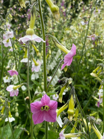
Schizanthus, Poor-Man's-Orchid, a plant native to Andes in South America, but just has happy in Northern California.
Oregon Border
The next day we set out for the most northwestern corner of California. The original goal of 2020 was not leave the state of California. However, COVID turned the goal into barely leaving the house. I came very close to achieving this goal and maybe crossed just barely into Oregon, Nevada and Arizona near the borders of the state.


Point St. George – Crescent City
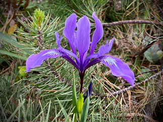
Heading back south, we were told to skip Crescent City, but we happened to notice that most Northwest point in California was located at Point St. George. We weren't expecting much, but when we headed out to the headlands we noticed there were tide pools and some nice rocks. Exploring more, we realized the rocks above the ocean had some nice Sedums growing on them mixed with wildflowers. Above the rocks grew native bunch grasses with large drifts of Western Iris and other wildflowers mixed in. We imagined that this is what much of coastal California must have looked like before the bunch grasses were outcompeted by introduced European annual grasses.


Blooming Sedum spathulifolium.

A very brightly yellow Creamcup, Platystemon.
They are in the poppy family and usually pale yellow.
Redwoods National Park
Heading further south, we took the alternate route to highway 101 which goes through several groves of old growth Redwood. We stopped to check out a restoration demonstration grove were they had removed an old logging road. We had the short trail and giant trees entirely to ourselves.


Patrick’s Point State Park – Humboldt County
The next day we went for a hike in Patrick's Point State Park. The park was just a mile or two north from where we were staying in Trinidad.

We headed down to the tide pools during low tide to search for starfish which we easily found due to their bright coloration.


One of things I wanted to find in the park were the Bishop Pines, Pinus muricata. They range from a few of the islands off of Baja along the coast all the way to Southern Oregon. They received the common name "Bishop Pine" since they were first identified near the mission San Luis Obispo (Bishop).


Twinberry Honeysuckle, Lonicera involucrata.
Lady Bird Johnson Grove
We did a quick stop in the afternoon at the somewhat famous Lady Bird Johnson Grove. It was a bit warmer and more crowded than other spots we had visited, but famous for being where Richard Nixon along with Lady Bird Johnson commemorated the creation of Redwood National Park, which made it a "must stop" on a trip iconic California places.


Western Azalea, Rhododendron occidentale, growing under the redwoods.
Fern Canyon
There were a lot of comments on my post on Facebook saying that we had to visit Fern Canyon. What they didn't tell us was that it was a very steep, winding and unpaved road with a couple of creek crossing to get there. We stopped short of the last creek crossing and walked the remainder of the way to the entrance to the canyon.
We weren't disappointed. Water seeps continually down the sides of the canyon walls creating perfect conditions for the ferns covered the walls above the small creek.


We spent our final evening in Trinidad checking out the little harbor in town and the well tended gardens of the homes above it.


Ferndale
The next morning we continued our journey south stopping to check out some of the Victorian homes in Humboldt and the nearby well preserved town of Ferndale.


Avenue of the Giants – Redwoods National Park
As we headed south along the "Avenue of the Giants" along the Eel River, the temperature started climbing again eventually reaching 102 degrees. Consequently, we made few stops but I couldn't resist dipping my toes into the cool water of the river.


Eventually we turned back towards the coast heading to Mendocino on a very winding, but mostly deserted road through the second growth forest. The temperature stayed very warm most of the way. However, when the road finally reached the coast, we were quite excited to see the cooling fog and the temperature had dropped into the upper 50s.

Mendocino
Our final night of the California Adventure was in a Bed and Breakfast in the charming town of old buildings and endless flower gardens, Mendocino. It was here we learned that every garden looks better with an old water tower in it.

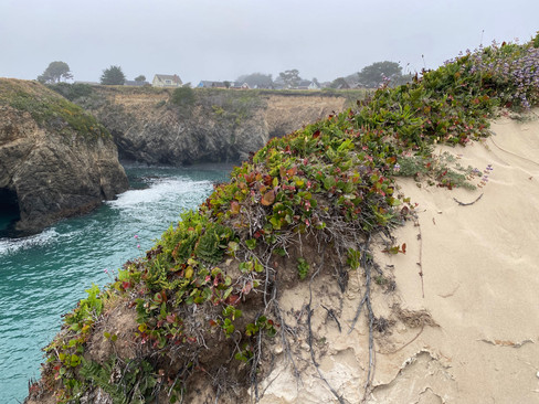
The town was somewhat deserted after the Memorial Day holiday and we had the headlands to ourselves to explore at sunset.

Mendocino Coast Botanical Garden – Garden by the Sea
Saving the best for last, we spent our last morning of the trip exploring the botanic garden in Mendocino.

The garden is well known for its collection of Rhododendrons.
There are also wonderful perennial beds and a massive kitchen garden.
So it's a wrap! Thanks for joining us on our Northern California adventure!


Comments